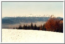
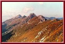
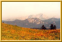
 Julian Alps from Kriska gora.
A relaxing, yet intense late winter view
of the Julian Alps from
the mountain hut just above the top of Kriska gora (1471m) is of course
dominated by Triglav, here seen
from the SE. But other features are also worth paying attention to,
even more so because the persistent winter fog, quite frequently
covering the valley of the Sava river for days or even weeks
without interruption, has dissolved. Rising above the valley
are black and brown slopes of Jelovica and the Pokljuka plateau,
the `purgatory' before the kingdom of Triglav and its neighbours,
but both on itself areas with abundant wildlife living in dense,
quiet (alas, at least outside the mushroom picking season) forests.
But we're still on Kriska gora, a nice, refreshing two or three hours'
walk from the village of Golnik, and the hut just above the top
offers the compulsory
jota and
zganci,
and some schnaps on top of it. Digesting them all, warming yourself
lying on a wooden bench, you will ponder upon your heroic ascents
long time gone and alpine enterprises yet to come...
Julian Alps from Kriska gora.
A relaxing, yet intense late winter view
of the Julian Alps from
the mountain hut just above the top of Kriska gora (1471m) is of course
dominated by Triglav, here seen
from the SE. But other features are also worth paying attention to,
even more so because the persistent winter fog, quite frequently
covering the valley of the Sava river for days or even weeks
without interruption, has dissolved. Rising above the valley
are black and brown slopes of Jelovica and the Pokljuka plateau,
the `purgatory' before the kingdom of Triglav and its neighbours,
but both on itself areas with abundant wildlife living in dense,
quiet (alas, at least outside the mushroom picking season) forests.
But we're still on Kriska gora, a nice, refreshing two or three hours'
walk from the village of Golnik, and the hut just above the top
offers the compulsory
jota and
zganci,
and some schnaps on top of it. Digesting them all, warming yourself
lying on a wooden bench, you will ponder upon your heroic ascents
long time gone and alpine enterprises yet to come...
|
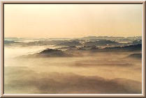 View from Kriska gora.
I will not bother to elaborate upon this
view from Kriska gora (1471m)
towards the southwest. The photo was taken somewhen in January when
the underlying valley of the Sava river was drowned in fog (actually,
what you see in the photo, is in a pretty fair condition - believe me,
I live in Ljubljana which has MUCH MORE fog). So no use in commenting
about the hills and slopes this photo tries to show; it is only meant
to be enjoyable.
View from Kriska gora.
I will not bother to elaborate upon this
view from Kriska gora (1471m)
towards the southwest. The photo was taken somewhen in January when
the underlying valley of the Sava river was drowned in fog (actually,
what you see in the photo, is in a pretty fair condition - believe me,
I live in Ljubljana which has MUCH MORE fog). So no use in commenting
about the hills and slopes this photo tries to show; it is only meant
to be enjoyable.
|
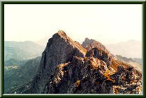
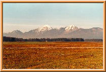 Storzic and Srednji vrh from SW.
Storzic (2132m) and its immediate
neighbour Srednji vrh (1853m),
here shown in late spring when the snow has already molten, are the
popular `local' mountains to the city of Kranj. Srednji vrh,
with its moderate final slope, is a frequently visited winter peak
with a magnificent, far reaching view and is full of surprises in any
of the four seasons. Maybe the most appealing time to visit is
late spring: only then will you be able to observe
primroses, the first
messengers of the awakening spring, and harshness of winter at the same time.
Storzic is more difficult to reach in winter, but in dry seasons,
ascents from all four directions are highly enjoyable.
Especially the path over Mala Poljana (the saddle between the
leftmost peak in the photo, Tolsti vrh (1715m), and Storzic) in summer,
is nothing but sheer pleasure: don't hesitate to lie down for an hour
or two amidst June flowers!
Storzic and Srednji vrh from SW.
Storzic (2132m) and its immediate
neighbour Srednji vrh (1853m),
here shown in late spring when the snow has already molten, are the
popular `local' mountains to the city of Kranj. Srednji vrh,
with its moderate final slope, is a frequently visited winter peak
with a magnificent, far reaching view and is full of surprises in any
of the four seasons. Maybe the most appealing time to visit is
late spring: only then will you be able to observe
primroses, the first
messengers of the awakening spring, and harshness of winter at the same time.
Storzic is more difficult to reach in winter, but in dry seasons,
ascents from all four directions are highly enjoyable.
Especially the path over Mala Poljana (the saddle between the
leftmost peak in the photo, Tolsti vrh (1715m), and Storzic) in summer,
is nothing but sheer pleasure: don't hesitate to lie down for an hour
or two amidst June flowers!
|
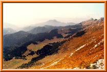
 Grintovci from Kosuta.
Kosuta (the name means `the female of a deer')
is about 10 kilometers long
mountain ridge with closely and evenly spaced peaks of about 2000m
altitude. The Slovenian-Austrian border runs exactly along this ridge.
On the southern side of the ridge, steep slopes covered with grass
prevail, whereas the northern side is sharply cut off and is completely
rocky (as usual in the Alps, where longer winter/spring frost because
of lack of sunshine causes northern faces of mountains disintegrate
much faster than the southern faces), in fact, the northern face is one
big, long wall, also praised by climbers. Even the southern side is
not quite without hidden dangers, though. The firm, long leaves of grass
are very slippery when wet! In winter, just after heavy snowfall,
and in spring, during the melting of snow, the downwards-combed turfs
of grass are ideal for snow layers to slip off and form avalanches.
The picture does not show Kosuta itself; it shows the view towards
the western part of the Kamniske Alpe,
known as Grintovci for its highest peak, Grintovec (2558m).
In the lower right corner, Tegoska planina (1430m) with Kisovec (1563m)
and Sklana pec (1440m).
Grintovci from Kosuta.
Kosuta (the name means `the female of a deer')
is about 10 kilometers long
mountain ridge with closely and evenly spaced peaks of about 2000m
altitude. The Slovenian-Austrian border runs exactly along this ridge.
On the southern side of the ridge, steep slopes covered with grass
prevail, whereas the northern side is sharply cut off and is completely
rocky (as usual in the Alps, where longer winter/spring frost because
of lack of sunshine causes northern faces of mountains disintegrate
much faster than the southern faces), in fact, the northern face is one
big, long wall, also praised by climbers. Even the southern side is
not quite without hidden dangers, though. The firm, long leaves of grass
are very slippery when wet! In winter, just after heavy snowfall,
and in spring, during the melting of snow, the downwards-combed turfs
of grass are ideal for snow layers to slip off and form avalanches.
The picture does not show Kosuta itself; it shows the view towards
the western part of the Kamniske Alpe,
known as Grintovci for its highest peak, Grintovec (2558m).
In the lower right corner, Tegoska planina (1430m) with Kisovec (1563m)
and Sklana pec (1440m).
|
 Alms under the Kosuta ridge.
There are quite a few `planinas'
(or Alms, as the Germans say) on the
more modest, southern side of the Kosuta ridge, and this photo shows
them all. Following with your eyes the slope of the last rocky peak
on the right side of the photo (Veliki vrh (==The Big Peak), 2088m)
until the ridge flattens brings you to the most well-known of them:
Kofce (1488m) with a small and friendly mountain hut serving all sorts
of meals. On the photo, Kofce can be seen as a small patch of grass.
Continuing towards east (which is towards you), you first encounter a
small indentation before you ascent a small bare hill again.
Behind it are the Planina Sija (1465m) and Planina Sija (1530m),
but you can not see them, because they're behind it. Approximately
in the geometrical centre of the photo is the Planina Pungrat (1447m)
from which the lowest point in the middle of the ridge, the pass of
Skrbina (1869m) can be reached. You can clearly see this discontinuity
in the ridge on the extreme right of the photo. In the lower left
corner of the photo, the Tegoska planina (1430m), and somewhere to
the left of where you are at the moment, but at approximately the
same altitude, Planina Dolga njiva (1400m), starting point for the
Kosutnikov turn (2134m), the highest peak of the Kosuta ridge.
You can conclude from altitudes of the Alms that even if you don't
have the strength or time to handle the main ridge, you can enjoy
the relaxing hike between them.
Alms under the Kosuta ridge.
There are quite a few `planinas'
(or Alms, as the Germans say) on the
more modest, southern side of the Kosuta ridge, and this photo shows
them all. Following with your eyes the slope of the last rocky peak
on the right side of the photo (Veliki vrh (==The Big Peak), 2088m)
until the ridge flattens brings you to the most well-known of them:
Kofce (1488m) with a small and friendly mountain hut serving all sorts
of meals. On the photo, Kofce can be seen as a small patch of grass.
Continuing towards east (which is towards you), you first encounter a
small indentation before you ascent a small bare hill again.
Behind it are the Planina Sija (1465m) and Planina Sija (1530m),
but you can not see them, because they're behind it. Approximately
in the geometrical centre of the photo is the Planina Pungrat (1447m)
from which the lowest point in the middle of the ridge, the pass of
Skrbina (1869m) can be reached. You can clearly see this discontinuity
in the ridge on the extreme right of the photo. In the lower left
corner of the photo, the Tegoska planina (1430m), and somewhere to
the left of where you are at the moment, but at approximately the
same altitude, Planina Dolga njiva (1400m), starting point for the
Kosutnikov turn (2134m), the highest peak of the Kosuta ridge.
You can conclude from altitudes of the Alms that even if you don't
have the strength or time to handle the main ridge, you can enjoy
the relaxing hike between them.
|
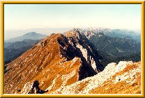
 The Kosuta Ridge.
This photo shows approximately one half
of the Kosuta ridge;
the direction of the view is towards the southwest (more to the west than
to the south). At the end of the ridge, the Veliki vrh (2088m),
then, nearer and nearer to the photographer's standpoint,
Kofce gora (or Mali turn) (1967m), Malo Kladivo (2036m), Kladivo (2094m)
(N.B. `Kladivo' means `a hammer'); then comes Skrbina (you get a
`skrbina' when someone knocks a tooth out of your jaw) with its 1869m,
situated about 400m above the Planina Pungrat. If you plan to start
your journey in the middle of the ridge ant not traverse it all in one go,
this is the right spot to choose. Also, the path from Skrbina to the
Planina Pungrat is the fastest (safe) way downhill in the case of
sudden bad weather. Finally, following Skrbina in the right portion
of the photo, Tegoska gora (2025m, 1956m).
The Kosuta Ridge.
This photo shows approximately one half
of the Kosuta ridge;
the direction of the view is towards the southwest (more to the west than
to the south). At the end of the ridge, the Veliki vrh (2088m),
then, nearer and nearer to the photographer's standpoint,
Kofce gora (or Mali turn) (1967m), Malo Kladivo (2036m), Kladivo (2094m)
(N.B. `Kladivo' means `a hammer'); then comes Skrbina (you get a
`skrbina' when someone knocks a tooth out of your jaw) with its 1869m,
situated about 400m above the Planina Pungrat. If you plan to start
your journey in the middle of the ridge ant not traverse it all in one go,
this is the right spot to choose. Also, the path from Skrbina to the
Planina Pungrat is the fastest (safe) way downhill in the case of
sudden bad weather. Finally, following Skrbina in the right portion
of the photo, Tegoska gora (2025m, 1956m).
|
 Kosutnikov turn.
This is the highest peak of the Kosuta ridge (2134m).
You can choose among
four ascents to it: two from the north (i.e. from the left on the photo),
following more or less daringly the natural passages of the north
face, dropping towards the Sele fara on the Austrian side of the border,
or two from the south, both starting at the alm of Dolga njiva (1400m)
directly underneath the peak to the south. The photo gives you
just a hint of the relaxing, serene atmosphere of this alm
- you can see its green meadows just on the extreme right edge - and of the
ragged, rocky, ridge contrasting it. Just behind the Kosutnikov turn
(`turn' means `tower') is the last peak in the Kosuta ridge,
the Tolsta Kosuta (2057m) (`tolsta' means something like `fat', but the
word sounds somewhat more gastronomically than geographically), and in the
distant background, hidden beneath the summer haze,
the Kamniske Alpe.
Kosutnikov turn.
This is the highest peak of the Kosuta ridge (2134m).
You can choose among
four ascents to it: two from the north (i.e. from the left on the photo),
following more or less daringly the natural passages of the north
face, dropping towards the Sele fara on the Austrian side of the border,
or two from the south, both starting at the alm of Dolga njiva (1400m)
directly underneath the peak to the south. The photo gives you
just a hint of the relaxing, serene atmosphere of this alm
- you can see its green meadows just on the extreme right edge - and of the
ragged, rocky, ridge contrasting it. Just behind the Kosutnikov turn
(`turn' means `tower') is the last peak in the Kosuta ridge,
the Tolsta Kosuta (2057m) (`tolsta' means something like `fat', but the
word sounds somewhat more gastronomically than geographically), and in the
distant background, hidden beneath the summer haze,
the Kamniske Alpe.
|
 The Kosuta ridge.
The same part of the ridge
as shown in the one but last photo (its western
part), but viewed directly from above Skrbina. Perhaps this photo shows
the contrast between the mellow, fragrant southern side and the more serious
northern side at its best. The rockies a certain distance farther away
towards west (right from the main ridge in the photo) are the group
of Stol, the highest peak of the Karavanke (`stol' means `chair');
Stol is accompanied by Vrtaca, Begunjscica and other smaller mountains.
Between the Kosuta ridge ending in Baba (1968m) just following Veliki vrh
and the Stol group is the border crossing to Austria, Ljubelj (1369m).
An old road used to lead over the Ljubelj pass for centuries,
until a new road and a tunnel about 200m lower were built during WWII
by the prisoners of a small Nazi concentration camp just below the pass.
A scenic, but still serpentine road now leads from the town of Trzic
on the Slovenian side to the first village, Unterloibl, on the Austrian side.
Many tourists passing the Ljubelj pass heading for the Slovenian,
Croatian seashore or other destinations, fail to notice the beauty of
the mountains they just passed by.
The Kosuta ridge.
The same part of the ridge
as shown in the one but last photo (its western
part), but viewed directly from above Skrbina. Perhaps this photo shows
the contrast between the mellow, fragrant southern side and the more serious
northern side at its best. The rockies a certain distance farther away
towards west (right from the main ridge in the photo) are the group
of Stol, the highest peak of the Karavanke (`stol' means `chair');
Stol is accompanied by Vrtaca, Begunjscica and other smaller mountains.
Between the Kosuta ridge ending in Baba (1968m) just following Veliki vrh
and the Stol group is the border crossing to Austria, Ljubelj (1369m).
An old road used to lead over the Ljubelj pass for centuries,
until a new road and a tunnel about 200m lower were built during WWII
by the prisoners of a small Nazi concentration camp just below the pass.
A scenic, but still serpentine road now leads from the town of Trzic
on the Slovenian side to the first village, Unterloibl, on the Austrian side.
Many tourists passing the Ljubelj pass heading for the Slovenian,
Croatian seashore or other destinations, fail to notice the beauty of
the mountains they just passed by.
|
 Storzic from Kosuta.
This late autumn view
was taken from the ridge of Kosuta towards the
southeast. The highest peak in the background is Storzic (2132m) and
at the extreme left edge of the photo, you can already see the first
stretches of the Kamniske Alpe with Kocna at the beginning.
Forrest-covered mountains in the foreground (going from the left) are
Kozji vrh (1628m), Stegovnik (1692m), Javorce (1667m) and
Kriska gora (mentioned above) at the extreme right, ending deep below
in the valley, at the town of Trzic. Although the forests in the
foreground came out a bit underexposed in the photo, the golden-brown
colour of the dried-out grass is fairly well reproduced. Late October is
the time to be here.
Storzic from Kosuta.
This late autumn view
was taken from the ridge of Kosuta towards the
southeast. The highest peak in the background is Storzic (2132m) and
at the extreme left edge of the photo, you can already see the first
stretches of the Kamniske Alpe with Kocna at the beginning.
Forrest-covered mountains in the foreground (going from the left) are
Kozji vrh (1628m), Stegovnik (1692m), Javorce (1667m) and
Kriska gora (mentioned above) at the extreme right, ending deep below
in the valley, at the town of Trzic. Although the forests in the
foreground came out a bit underexposed in the photo, the golden-brown
colour of the dried-out grass is fairly well reproduced. Late October is
the time to be here.
|
 Grintovci from Kofce.
Another view from the Kosuta region,
this time from the alm of Kofce towards Grintovci (the main part of the
Kamniske Alpe).
In the foreground, Stegovnik (1692m) and in the background, starting from
the right, Kalska gora (2224m), Kokrsko sedlo (1759m), and then the
main part of Grintovci, Kocna, Grintovec and the rest of the ridge towards
the east. The photo shows a late-autumn, late-afternoon photo of
the region; in just a few weeks or in a month or so, this whole place
will be covered with snow and immersed in winter sleep.
Grintovci from Kofce.
Another view from the Kosuta region,
this time from the alm of Kofce towards Grintovci (the main part of the
Kamniske Alpe).
In the foreground, Stegovnik (1692m) and in the background, starting from
the right, Kalska gora (2224m), Kokrsko sedlo (1759m), and then the
main part of Grintovci, Kocna, Grintovec and the rest of the ridge towards
the east. The photo shows a late-autumn, late-afternoon photo of
the region; in just a few weeks or in a month or so, this whole place
will be covered with snow and immersed in winter sleep.
|
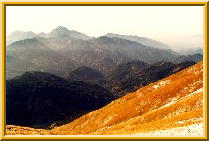
 View from Olseva.
Olseva is a mountain with the main peak
reaching 1927m in the
Kamnisko-Savinjske Alps, and is most well-known for its prehistoric
findings. There is a cave at an about 1500m altitude where numerous
animal bones and skeletons were found (this photo is taken approximately
from that point -- just imagine a cave bear overlooking the valley
below and the mountains around him on a sunny Sunday afternoon!).
What you can see from here is the Logarska dolina (the valley with
the little green lawn at the bottom), Matkov kot (the valley without
the lawn), and practically the whole main ridge of Kamniske Alpe,
starting with Storzic at the left, Kocna at the right edge
and Planjava, Brana, Turska gora, Rinke, Skuta, Dolgi hrbet
and Grintovec in between. I know it's small, but it's beautiful.
View from Olseva.
Olseva is a mountain with the main peak
reaching 1927m in the
Kamnisko-Savinjske Alps, and is most well-known for its prehistoric
findings. There is a cave at an about 1500m altitude where numerous
animal bones and skeletons were found (this photo is taken approximately
from that point -- just imagine a cave bear overlooking the valley
below and the mountains around him on a sunny Sunday afternoon!).
What you can see from here is the Logarska dolina (the valley with
the little green lawn at the bottom), Matkov kot (the valley without
the lawn), and practically the whole main ridge of Kamniske Alpe,
starting with Storzic at the left, Kocna at the right edge
and Planjava, Brana, Turska gora, Rinke, Skuta, Dolgi hrbet
and Grintovec in between. I know it's small, but it's beautiful.
|
 View from Struska.
Struska (1944m) is another fine peak you can
relatively easily enjoy in winter without fear of falling into some dangerous
pit or snow crack. Struska is a border mountain; the mountain you see
on the left side of the photo, already belongs to Austria. It is
called Ovcji vrh (or Geißberg, or The Peak of Sheep) and overlooks
the Bärental (or The Bear's valley). The ridge in the distant
background on the left is the Kosuta mentioned above. In the centre
of the photo, Vrtaca, and on the right, with the northern wall
hidden in shadows, Stol. To make the situation clear, except for
the top of Ovcji vrh, Austria is in the shadow and Slovenia is sunlit.
As we like to say, on the sunny side of the Alps.
View from Struska.
Struska (1944m) is another fine peak you can
relatively easily enjoy in winter without fear of falling into some dangerous
pit or snow crack. Struska is a border mountain; the mountain you see
on the left side of the photo, already belongs to Austria. It is
called Ovcji vrh (or Geißberg, or The Peak of Sheep) and overlooks
the Bärental (or The Bear's valley). The ridge in the distant
background on the left is the Kosuta mentioned above. In the centre
of the photo, Vrtaca, and on the right, with the northern wall
hidden in shadows, Stol. To make the situation clear, except for
the top of Ovcji vrh, Austria is in the shadow and Slovenia is sunlit.
As we like to say, on the sunny side of the Alps.
|
 Julian Alps from Kriska gora.
A relaxing, yet intense late winter view
of the Julian Alps from
the mountain hut just above the top of Kriska gora (1471m) is of course
dominated by Triglav, here seen
from the SE. But other features are also worth paying attention to,
even more so because the persistent winter fog, quite frequently
covering the valley of the Sava river for days or even weeks
without interruption, has dissolved. Rising above the valley
are black and brown slopes of Jelovica and the Pokljuka plateau,
the `purgatory' before the kingdom of Triglav and its neighbours,
but both on itself areas with abundant wildlife living in dense,
quiet (alas, at least outside the mushroom picking season) forests.
But we're still on Kriska gora, a nice, refreshing two or three hours'
walk from the village of Golnik, and the hut just above the top
offers the compulsory
jota and
zganci,
and some schnaps on top of it. Digesting them all, warming yourself
lying on a wooden bench, you will ponder upon your heroic ascents
long time gone and alpine enterprises yet to come...
Julian Alps from Kriska gora.
A relaxing, yet intense late winter view
of the Julian Alps from
the mountain hut just above the top of Kriska gora (1471m) is of course
dominated by Triglav, here seen
from the SE. But other features are also worth paying attention to,
even more so because the persistent winter fog, quite frequently
covering the valley of the Sava river for days or even weeks
without interruption, has dissolved. Rising above the valley
are black and brown slopes of Jelovica and the Pokljuka plateau,
the `purgatory' before the kingdom of Triglav and its neighbours,
but both on itself areas with abundant wildlife living in dense,
quiet (alas, at least outside the mushroom picking season) forests.
But we're still on Kriska gora, a nice, refreshing two or three hours'
walk from the village of Golnik, and the hut just above the top
offers the compulsory
jota and
zganci,
and some schnaps on top of it. Digesting them all, warming yourself
lying on a wooden bench, you will ponder upon your heroic ascents
long time gone and alpine enterprises yet to come...
 View from Kriska gora.
I will not bother to elaborate upon this
view from Kriska gora (1471m)
towards the southwest. The photo was taken somewhen in January when
the underlying valley of the Sava river was drowned in fog (actually,
what you see in the photo, is in a pretty fair condition - believe me,
I live in Ljubljana which has MUCH MORE fog). So no use in commenting
about the hills and slopes this photo tries to show; it is only meant
to be enjoyable.
View from Kriska gora.
I will not bother to elaborate upon this
view from Kriska gora (1471m)
towards the southwest. The photo was taken somewhen in January when
the underlying valley of the Sava river was drowned in fog (actually,
what you see in the photo, is in a pretty fair condition - believe me,
I live in Ljubljana which has MUCH MORE fog). So no use in commenting
about the hills and slopes this photo tries to show; it is only meant
to be enjoyable.
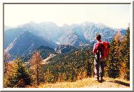
 Storzic and Srednji vrh from SW.
Storzic (2132m) and its immediate
neighbour Srednji vrh (1853m),
here shown in late spring when the snow has already molten, are the
popular `local' mountains to the city of Kranj. Srednji vrh,
with its moderate final slope, is a frequently visited winter peak
with a magnificent, far reaching view and is full of surprises in any
of the four seasons. Maybe the most appealing time to visit is
late spring: only then will you be able to observe
primroses, the first
messengers of the awakening spring, and harshness of winter at the same time.
Storzic is more difficult to reach in winter, but in dry seasons,
ascents from all four directions are highly enjoyable.
Especially the path over Mala Poljana (the saddle between the
leftmost peak in the photo, Tolsti vrh (1715m), and Storzic) in summer,
is nothing but sheer pleasure: don't hesitate to lie down for an hour
or two amidst June flowers!
Storzic and Srednji vrh from SW.
Storzic (2132m) and its immediate
neighbour Srednji vrh (1853m),
here shown in late spring when the snow has already molten, are the
popular `local' mountains to the city of Kranj. Srednji vrh,
with its moderate final slope, is a frequently visited winter peak
with a magnificent, far reaching view and is full of surprises in any
of the four seasons. Maybe the most appealing time to visit is
late spring: only then will you be able to observe
primroses, the first
messengers of the awakening spring, and harshness of winter at the same time.
Storzic is more difficult to reach in winter, but in dry seasons,
ascents from all four directions are highly enjoyable.
Especially the path over Mala Poljana (the saddle between the
leftmost peak in the photo, Tolsti vrh (1715m), and Storzic) in summer,
is nothing but sheer pleasure: don't hesitate to lie down for an hour
or two amidst June flowers!
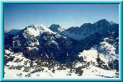
 Grintovci from Kosuta.
Kosuta (the name means `the female of a deer')
is about 10 kilometers long
mountain ridge with closely and evenly spaced peaks of about 2000m
altitude. The Slovenian-Austrian border runs exactly along this ridge.
On the southern side of the ridge, steep slopes covered with grass
prevail, whereas the northern side is sharply cut off and is completely
rocky (as usual in the Alps, where longer winter/spring frost because
of lack of sunshine causes northern faces of mountains disintegrate
much faster than the southern faces), in fact, the northern face is one
big, long wall, also praised by climbers. Even the southern side is
not quite without hidden dangers, though. The firm, long leaves of grass
are very slippery when wet! In winter, just after heavy snowfall,
and in spring, during the melting of snow, the downwards-combed turfs
of grass are ideal for snow layers to slip off and form avalanches.
The picture does not show Kosuta itself; it shows the view towards
the western part of the Kamniske Alpe,
known as Grintovci for its highest peak, Grintovec (2558m).
In the lower right corner, Tegoska planina (1430m) with Kisovec (1563m)
and Sklana pec (1440m).
Grintovci from Kosuta.
Kosuta (the name means `the female of a deer')
is about 10 kilometers long
mountain ridge with closely and evenly spaced peaks of about 2000m
altitude. The Slovenian-Austrian border runs exactly along this ridge.
On the southern side of the ridge, steep slopes covered with grass
prevail, whereas the northern side is sharply cut off and is completely
rocky (as usual in the Alps, where longer winter/spring frost because
of lack of sunshine causes northern faces of mountains disintegrate
much faster than the southern faces), in fact, the northern face is one
big, long wall, also praised by climbers. Even the southern side is
not quite without hidden dangers, though. The firm, long leaves of grass
are very slippery when wet! In winter, just after heavy snowfall,
and in spring, during the melting of snow, the downwards-combed turfs
of grass are ideal for snow layers to slip off and form avalanches.
The picture does not show Kosuta itself; it shows the view towards
the western part of the Kamniske Alpe,
known as Grintovci for its highest peak, Grintovec (2558m).
In the lower right corner, Tegoska planina (1430m) with Kisovec (1563m)
and Sklana pec (1440m).
 Alms under the Kosuta ridge.
There are quite a few `planinas'
(or Alms, as the Germans say) on the
more modest, southern side of the Kosuta ridge, and this photo shows
them all. Following with your eyes the slope of the last rocky peak
on the right side of the photo (Veliki vrh (==The Big Peak), 2088m)
until the ridge flattens brings you to the most well-known of them:
Kofce (1488m) with a small and friendly mountain hut serving all sorts
of meals. On the photo, Kofce can be seen as a small patch of grass.
Continuing towards east (which is towards you), you first encounter a
small indentation before you ascent a small bare hill again.
Behind it are the Planina Sija (1465m) and Planina Sija (1530m),
but you can not see them, because they're behind it. Approximately
in the geometrical centre of the photo is the Planina Pungrat (1447m)
from which the lowest point in the middle of the ridge, the pass of
Skrbina (1869m) can be reached. You can clearly see this discontinuity
in the ridge on the extreme right of the photo. In the lower left
corner of the photo, the Tegoska planina (1430m), and somewhere to
the left of where you are at the moment, but at approximately the
same altitude, Planina Dolga njiva (1400m), starting point for the
Kosutnikov turn (2134m), the highest peak of the Kosuta ridge.
You can conclude from altitudes of the Alms that even if you don't
have the strength or time to handle the main ridge, you can enjoy
the relaxing hike between them.
Alms under the Kosuta ridge.
There are quite a few `planinas'
(or Alms, as the Germans say) on the
more modest, southern side of the Kosuta ridge, and this photo shows
them all. Following with your eyes the slope of the last rocky peak
on the right side of the photo (Veliki vrh (==The Big Peak), 2088m)
until the ridge flattens brings you to the most well-known of them:
Kofce (1488m) with a small and friendly mountain hut serving all sorts
of meals. On the photo, Kofce can be seen as a small patch of grass.
Continuing towards east (which is towards you), you first encounter a
small indentation before you ascent a small bare hill again.
Behind it are the Planina Sija (1465m) and Planina Sija (1530m),
but you can not see them, because they're behind it. Approximately
in the geometrical centre of the photo is the Planina Pungrat (1447m)
from which the lowest point in the middle of the ridge, the pass of
Skrbina (1869m) can be reached. You can clearly see this discontinuity
in the ridge on the extreme right of the photo. In the lower left
corner of the photo, the Tegoska planina (1430m), and somewhere to
the left of where you are at the moment, but at approximately the
same altitude, Planina Dolga njiva (1400m), starting point for the
Kosutnikov turn (2134m), the highest peak of the Kosuta ridge.
You can conclude from altitudes of the Alms that even if you don't
have the strength or time to handle the main ridge, you can enjoy
the relaxing hike between them.
 The Kosuta Ridge.
This photo shows approximately one half
of the Kosuta ridge;
the direction of the view is towards the southwest (more to the west than
to the south). At the end of the ridge, the Veliki vrh (2088m),
then, nearer and nearer to the photographer's standpoint,
Kofce gora (or Mali turn) (1967m), Malo Kladivo (2036m), Kladivo (2094m)
(N.B. `Kladivo' means `a hammer'); then comes Skrbina (you get a
`skrbina' when someone knocks a tooth out of your jaw) with its 1869m,
situated about 400m above the Planina Pungrat. If you plan to start
your journey in the middle of the ridge ant not traverse it all in one go,
this is the right spot to choose. Also, the path from Skrbina to the
Planina Pungrat is the fastest (safe) way downhill in the case of
sudden bad weather. Finally, following Skrbina in the right portion
of the photo, Tegoska gora (2025m, 1956m).
The Kosuta Ridge.
This photo shows approximately one half
of the Kosuta ridge;
the direction of the view is towards the southwest (more to the west than
to the south). At the end of the ridge, the Veliki vrh (2088m),
then, nearer and nearer to the photographer's standpoint,
Kofce gora (or Mali turn) (1967m), Malo Kladivo (2036m), Kladivo (2094m)
(N.B. `Kladivo' means `a hammer'); then comes Skrbina (you get a
`skrbina' when someone knocks a tooth out of your jaw) with its 1869m,
situated about 400m above the Planina Pungrat. If you plan to start
your journey in the middle of the ridge ant not traverse it all in one go,
this is the right spot to choose. Also, the path from Skrbina to the
Planina Pungrat is the fastest (safe) way downhill in the case of
sudden bad weather. Finally, following Skrbina in the right portion
of the photo, Tegoska gora (2025m, 1956m).
 Kosutnikov turn.
This is the highest peak of the Kosuta ridge (2134m).
You can choose among
four ascents to it: two from the north (i.e. from the left on the photo),
following more or less daringly the natural passages of the north
face, dropping towards the Sele fara on the Austrian side of the border,
or two from the south, both starting at the alm of Dolga njiva (1400m)
directly underneath the peak to the south. The photo gives you
just a hint of the relaxing, serene atmosphere of this alm
- you can see its green meadows just on the extreme right edge - and of the
ragged, rocky, ridge contrasting it. Just behind the Kosutnikov turn
(`turn' means `tower') is the last peak in the Kosuta ridge,
the Tolsta Kosuta (2057m) (`tolsta' means something like `fat', but the
word sounds somewhat more gastronomically than geographically), and in the
distant background, hidden beneath the summer haze,
the Kamniske Alpe.
Kosutnikov turn.
This is the highest peak of the Kosuta ridge (2134m).
You can choose among
four ascents to it: two from the north (i.e. from the left on the photo),
following more or less daringly the natural passages of the north
face, dropping towards the Sele fara on the Austrian side of the border,
or two from the south, both starting at the alm of Dolga njiva (1400m)
directly underneath the peak to the south. The photo gives you
just a hint of the relaxing, serene atmosphere of this alm
- you can see its green meadows just on the extreme right edge - and of the
ragged, rocky, ridge contrasting it. Just behind the Kosutnikov turn
(`turn' means `tower') is the last peak in the Kosuta ridge,
the Tolsta Kosuta (2057m) (`tolsta' means something like `fat', but the
word sounds somewhat more gastronomically than geographically), and in the
distant background, hidden beneath the summer haze,
the Kamniske Alpe.
 The Kosuta ridge.
The same part of the ridge
as shown in the one but last photo (its western
part), but viewed directly from above Skrbina. Perhaps this photo shows
the contrast between the mellow, fragrant southern side and the more serious
northern side at its best. The rockies a certain distance farther away
towards west (right from the main ridge in the photo) are the group
of Stol, the highest peak of the Karavanke (`stol' means `chair');
Stol is accompanied by Vrtaca, Begunjscica and other smaller mountains.
Between the Kosuta ridge ending in Baba (1968m) just following Veliki vrh
and the Stol group is the border crossing to Austria, Ljubelj (1369m).
An old road used to lead over the Ljubelj pass for centuries,
until a new road and a tunnel about 200m lower were built during WWII
by the prisoners of a small Nazi concentration camp just below the pass.
A scenic, but still serpentine road now leads from the town of Trzic
on the Slovenian side to the first village, Unterloibl, on the Austrian side.
Many tourists passing the Ljubelj pass heading for the Slovenian,
Croatian seashore or other destinations, fail to notice the beauty of
the mountains they just passed by.
The Kosuta ridge.
The same part of the ridge
as shown in the one but last photo (its western
part), but viewed directly from above Skrbina. Perhaps this photo shows
the contrast between the mellow, fragrant southern side and the more serious
northern side at its best. The rockies a certain distance farther away
towards west (right from the main ridge in the photo) are the group
of Stol, the highest peak of the Karavanke (`stol' means `chair');
Stol is accompanied by Vrtaca, Begunjscica and other smaller mountains.
Between the Kosuta ridge ending in Baba (1968m) just following Veliki vrh
and the Stol group is the border crossing to Austria, Ljubelj (1369m).
An old road used to lead over the Ljubelj pass for centuries,
until a new road and a tunnel about 200m lower were built during WWII
by the prisoners of a small Nazi concentration camp just below the pass.
A scenic, but still serpentine road now leads from the town of Trzic
on the Slovenian side to the first village, Unterloibl, on the Austrian side.
Many tourists passing the Ljubelj pass heading for the Slovenian,
Croatian seashore or other destinations, fail to notice the beauty of
the mountains they just passed by.
 Storzic from Kosuta.
This late autumn view
was taken from the ridge of Kosuta towards the
southeast. The highest peak in the background is Storzic (2132m) and
at the extreme left edge of the photo, you can already see the first
stretches of the Kamniske Alpe with Kocna at the beginning.
Forrest-covered mountains in the foreground (going from the left) are
Kozji vrh (1628m), Stegovnik (1692m), Javorce (1667m) and
Kriska gora (mentioned above) at the extreme right, ending deep below
in the valley, at the town of Trzic. Although the forests in the
foreground came out a bit underexposed in the photo, the golden-brown
colour of the dried-out grass is fairly well reproduced. Late October is
the time to be here.
Storzic from Kosuta.
This late autumn view
was taken from the ridge of Kosuta towards the
southeast. The highest peak in the background is Storzic (2132m) and
at the extreme left edge of the photo, you can already see the first
stretches of the Kamniske Alpe with Kocna at the beginning.
Forrest-covered mountains in the foreground (going from the left) are
Kozji vrh (1628m), Stegovnik (1692m), Javorce (1667m) and
Kriska gora (mentioned above) at the extreme right, ending deep below
in the valley, at the town of Trzic. Although the forests in the
foreground came out a bit underexposed in the photo, the golden-brown
colour of the dried-out grass is fairly well reproduced. Late October is
the time to be here.
 Grintovci from Kofce.
Another view from the Kosuta region,
this time from the alm of Kofce towards Grintovci (the main part of the
Kamniske Alpe).
In the foreground, Stegovnik (1692m) and in the background, starting from
the right, Kalska gora (2224m), Kokrsko sedlo (1759m), and then the
main part of Grintovci, Kocna, Grintovec and the rest of the ridge towards
the east. The photo shows a late-autumn, late-afternoon photo of
the region; in just a few weeks or in a month or so, this whole place
will be covered with snow and immersed in winter sleep.
Grintovci from Kofce.
Another view from the Kosuta region,
this time from the alm of Kofce towards Grintovci (the main part of the
Kamniske Alpe).
In the foreground, Stegovnik (1692m) and in the background, starting from
the right, Kalska gora (2224m), Kokrsko sedlo (1759m), and then the
main part of Grintovci, Kocna, Grintovec and the rest of the ridge towards
the east. The photo shows a late-autumn, late-afternoon photo of
the region; in just a few weeks or in a month or so, this whole place
will be covered with snow and immersed in winter sleep.
 View from Olseva.
Olseva is a mountain with the main peak
reaching 1927m in the
Kamnisko-Savinjske Alps, and is most well-known for its prehistoric
findings. There is a cave at an about 1500m altitude where numerous
animal bones and skeletons were found (this photo is taken approximately
from that point -- just imagine a cave bear overlooking the valley
below and the mountains around him on a sunny Sunday afternoon!).
What you can see from here is the Logarska dolina (the valley with
the little green lawn at the bottom), Matkov kot (the valley without
the lawn), and practically the whole main ridge of Kamniske Alpe,
starting with Storzic at the left, Kocna at the right edge
and Planjava, Brana, Turska gora, Rinke, Skuta, Dolgi hrbet
and Grintovec in between. I know it's small, but it's beautiful.
View from Olseva.
Olseva is a mountain with the main peak
reaching 1927m in the
Kamnisko-Savinjske Alps, and is most well-known for its prehistoric
findings. There is a cave at an about 1500m altitude where numerous
animal bones and skeletons were found (this photo is taken approximately
from that point -- just imagine a cave bear overlooking the valley
below and the mountains around him on a sunny Sunday afternoon!).
What you can see from here is the Logarska dolina (the valley with
the little green lawn at the bottom), Matkov kot (the valley without
the lawn), and practically the whole main ridge of Kamniske Alpe,
starting with Storzic at the left, Kocna at the right edge
and Planjava, Brana, Turska gora, Rinke, Skuta, Dolgi hrbet
and Grintovec in between. I know it's small, but it's beautiful.
 View from Struska.
Struska (1944m) is another fine peak you can
relatively easily enjoy in winter without fear of falling into some dangerous
pit or snow crack. Struska is a border mountain; the mountain you see
on the left side of the photo, already belongs to Austria. It is
called Ovcji vrh (or Geißberg, or The Peak of Sheep) and overlooks
the Bärental (or The Bear's valley). The ridge in the distant
background on the left is the Kosuta mentioned above. In the centre
of the photo, Vrtaca, and on the right, with the northern wall
hidden in shadows, Stol. To make the situation clear, except for
the top of Ovcji vrh, Austria is in the shadow and Slovenia is sunlit.
As we like to say, on the sunny side of the Alps.
View from Struska.
Struska (1944m) is another fine peak you can
relatively easily enjoy in winter without fear of falling into some dangerous
pit or snow crack. Struska is a border mountain; the mountain you see
on the left side of the photo, already belongs to Austria. It is
called Ovcji vrh (or Geißberg, or The Peak of Sheep) and overlooks
the Bärental (or The Bear's valley). The ridge in the distant
background on the left is the Kosuta mentioned above. In the centre
of the photo, Vrtaca, and on the right, with the northern wall
hidden in shadows, Stol. To make the situation clear, except for
the top of Ovcji vrh, Austria is in the shadow and Slovenia is sunlit.
As we like to say, on the sunny side of the Alps.