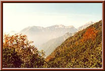
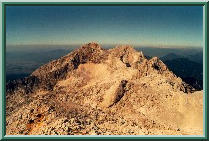
 Kalski greben from Presedlaj.
This late autumn photo shows the
westernmost part of Kamniske Alpe
as seen from the saddle point of Presedlaj (1613m). The mountains on
the left are Mokrica (1853m), Kompotela (1989m) and Vrh korena (1999m),
and in the middle of the photo Kalski greben (2224m) and Kalska gora (2058m).
The lowest point in the ridge, just where the pyramid of Grintovec (2558m)
starts to rise, is the Kokrsko sedlo (1791m). This point (`sedlo' means
`saddle') is a very peculiar passage from the valley of the small rivers
Kamniska bistrica on the east (this side of the ridge shown) and of the
Kokra on the west (other side of the ridge). The ascent from the west is
scented by rocks and walls above your head and cast into deep snow and
hard ice during the winter; the ascent from the west is much friendlier,
especially in the summer: the beautiful meadows and pastures
owned by an old native, Suhadolnik, take you to the saddle before
you could say `cookie'.
Kalski greben from Presedlaj.
This late autumn photo shows the
westernmost part of Kamniske Alpe
as seen from the saddle point of Presedlaj (1613m). The mountains on
the left are Mokrica (1853m), Kompotela (1989m) and Vrh korena (1999m),
and in the middle of the photo Kalski greben (2224m) and Kalska gora (2058m).
The lowest point in the ridge, just where the pyramid of Grintovec (2558m)
starts to rise, is the Kokrsko sedlo (1791m). This point (`sedlo' means
`saddle') is a very peculiar passage from the valley of the small rivers
Kamniska bistrica on the east (this side of the ridge shown) and of the
Kokra on the west (other side of the ridge). The ascent from the west is
scented by rocks and walls above your head and cast into deep snow and
hard ice during the winter; the ascent from the west is much friendlier,
especially in the summer: the beautiful meadows and pastures
owned by an old native, Suhadolnik, take you to the saddle before
you could say `cookie'.
|
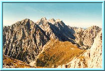 Brana and Kamnisko sedlo from Planjava.
Another, probably the most famous mountain
saddle in Slovenia, is the
Kamnisko sedlo (1884m), also called The Jerman's Door. The most popular
path to it leads from Kamniska bistrica in the south past Pastirci (1420m).
The protruding rocks at the bottom of the zig-zaggy path are just
about half-way from Pastirci to the saddle; when you're tired (say, in
the merciless summer sun which shines directly into your neck) or when
you're half lost in the winter mist, these rocks are a useful checkpoint.
But the real fun starts at the saddle, not below it. The Jerman's Door
is namely a good starting point for the whole area of Grintovci,
the mountain group named after Grintovec (2558m), its highest peak.
On the photo, from the left: Brana (2253m), the Jerman's Door's
`local' peak (but beware its treacherous northern slopes in winter
-- they end up smoothly somewhere half a mile below), Skuta (2532m),
and three Rinke. On the extreme right, the crumbly Mrzli vrh (2094m)
and Mrzla gora (2203m).
Brana and Kamnisko sedlo from Planjava.
Another, probably the most famous mountain
saddle in Slovenia, is the
Kamnisko sedlo (1884m), also called The Jerman's Door. The most popular
path to it leads from Kamniska bistrica in the south past Pastirci (1420m).
The protruding rocks at the bottom of the zig-zaggy path are just
about half-way from Pastirci to the saddle; when you're tired (say, in
the merciless summer sun which shines directly into your neck) or when
you're half lost in the winter mist, these rocks are a useful checkpoint.
But the real fun starts at the saddle, not below it. The Jerman's Door
is namely a good starting point for the whole area of Grintovci,
the mountain group named after Grintovec (2558m), its highest peak.
On the photo, from the left: Brana (2253m), the Jerman's Door's
`local' peak (but beware its treacherous northern slopes in winter
-- they end up smoothly somewhere half a mile below), Skuta (2532m),
and three Rinke. On the extreme right, the crumbly Mrzli vrh (2094m)
and Mrzla gora (2203m).
|
 Kalska gora and Kalski greben from Podi.
Kalska gora (left, 2058m) and Kalski greben
(2224m, right) are here seen
from the small plateau of Podi just below the top pyramid of Grintovec
(2558m). This is a late summer photo and the sun is just rising so that
the ridge is lit from the east. The western face oversees the Kokra valley
and the pleasant Suhi dol (the grassy slopes above the Suhadolnik's
farm, which can also be reached through an unpaved road from Kokra).
At the end of the ridge, at the extreme left and down, is the Kokrsko sedlo
with a mountain hut (1791m), a standard resting place on your way to either
the top of Kalska gora and Kalski greben or on your way to Grintovec.
If you follow the ridge towards the south, it will eventually bring you
to Koren, Kompotela and Mokrica, the last significant stretches of
Kamniske alpe to the south. But even as an individual goal, these two
(slightly off-the-beaten-track) mountains are a real pleasure.
Kalska gora and Kalski greben from Podi.
Kalska gora (left, 2058m) and Kalski greben
(2224m, right) are here seen
from the small plateau of Podi just below the top pyramid of Grintovec
(2558m). This is a late summer photo and the sun is just rising so that
the ridge is lit from the east. The western face oversees the Kokra valley
and the pleasant Suhi dol (the grassy slopes above the Suhadolnik's
farm, which can also be reached through an unpaved road from Kokra).
At the end of the ridge, at the extreme left and down, is the Kokrsko sedlo
with a mountain hut (1791m), a standard resting place on your way to either
the top of Kalska gora and Kalski greben or on your way to Grintovec.
If you follow the ridge towards the south, it will eventually bring you
to Koren, Kompotela and Mokrica, the last significant stretches of
Kamniske alpe to the south. But even as an individual goal, these two
(slightly off-the-beaten-track) mountains are a real pleasure.
|
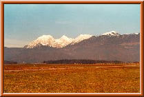 Grintovci from the south.
An overall, early spring view of
Grintovci from the Sava valley.
From the left, Kocna (2540m) and Grintovec (2558m). Some people
tend to misidentify the saddle between them as Kamnisko sedlo
(Jerman's Door). It is a saddle indeed, but it is called Mlinarsko sedlo
and is more difficult to reach. Next comes Kalski greben with its
characteristic, slow rise, and at the end, the rounded Krvavec (1853m),
which is a big ski resort, and an almost compulsory meeting-point
for skiing enthusiasts from Kranj, Ljubljana and whole Slovenia.
A very popular thing to hear in Ljubljana's offices (but don't tell
it to anyone) at 11 AM: ``Let's go on the afternoon's''
(meaning: let's go to ski on Krvavec from 12 AM to 4 PM; work can wait).
Grintovci from the south.
An overall, early spring view of
Grintovci from the Sava valley.
From the left, Kocna (2540m) and Grintovec (2558m). Some people
tend to misidentify the saddle between them as Kamnisko sedlo
(Jerman's Door). It is a saddle indeed, but it is called Mlinarsko sedlo
and is more difficult to reach. Next comes Kalski greben with its
characteristic, slow rise, and at the end, the rounded Krvavec (1853m),
which is a big ski resort, and an almost compulsory meeting-point
for skiing enthusiasts from Kranj, Ljubljana and whole Slovenia.
A very popular thing to hear in Ljubljana's offices (but don't tell
it to anyone) at 11 AM: ``Let's go on the afternoon's''
(meaning: let's go to ski on Krvavec from 12 AM to 4 PM; work can wait).
|
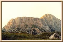
 Grintovec from Skuta.
A very instructive, high-summer view from Skuta (2532m),
one of the central peaks of the Grintovci group, to the west.
There are many interesting features to be seen here: first, the challenging
pyramid of Grintovec (its southwestern side, which is hidden behind the
edge, is also called `the roof') looks fine now, but becomes more
dangerous and tricky in winter. To the right is the peak of Kocna (2540m);
the peaks are connected through the Mlinarsko sedlo. In the far background,
Julijske alpe with Triglav (2864m). Two cool things in the foreground:
the red colour of the rocks in the lower left corner of the photo
means that they contain iron in abundance (beware in case of lighting!);
the big oblique rock in the centre of the photo looks like
a piece of rock from above, but from below, it in fact gives an
impression of a real peak. It is called Struca (2457m) and
it resembles a loaf of bread from if viewed from any direction.
Indeed, `struca' means `loaf'.
Grintovec from Skuta.
A very instructive, high-summer view from Skuta (2532m),
one of the central peaks of the Grintovci group, to the west.
There are many interesting features to be seen here: first, the challenging
pyramid of Grintovec (its southwestern side, which is hidden behind the
edge, is also called `the roof') looks fine now, but becomes more
dangerous and tricky in winter. To the right is the peak of Kocna (2540m);
the peaks are connected through the Mlinarsko sedlo. In the far background,
Julijske alpe with Triglav (2864m). Two cool things in the foreground:
the red colour of the rocks in the lower left corner of the photo
means that they contain iron in abundance (beware in case of lighting!);
the big oblique rock in the centre of the photo looks like
a piece of rock from above, but from below, it in fact gives an
impression of a real peak. It is called Struca (2457m) and
it resembles a loaf of bread from if viewed from any direction.
Indeed, `struca' means `loaf'.
|
 Storzic from Krvavec.
Remember the fog above the Sava river valley
I mentioned in the page
about Karavanke? This is how it looks like in winter when
the temperature inversion keeping the cold air close to the ground
and warm air at altitudes above 500, 600 metres or so, can persist
for days or even weeks. This evening photo was taken from Krvavec,
the popular ski resort at the northeastern edge of the Sava river valley,
about 35 kilometres from Ljubljana. Far behind is Storzic (2132m)
with Srednji vrh in the front. Observe the low clouds how they
spill over the ridges.
Storzic from Krvavec.
Remember the fog above the Sava river valley
I mentioned in the page
about Karavanke? This is how it looks like in winter when
the temperature inversion keeping the cold air close to the ground
and warm air at altitudes above 500, 600 metres or so, can persist
for days or even weeks. This evening photo was taken from Krvavec,
the popular ski resort at the northeastern edge of the Sava river valley,
about 35 kilometres from Ljubljana. Far behind is Storzic (2132m)
with Srednji vrh in the front. Observe the low clouds how they
spill over the ridges.
|
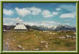 Velika planina.
Velika planina is an alpine `Alm',
and is in fact a plateau stretched
over a few kilometres at an altitude of about 1500 metres. It is
similarly close to Ljubljana, about 30 kilometres or so, and is a
popular sunday `stroll' for many families and non-demanding hikers.
There's also a cable car that takes you here in five minutes,
but the path over St. Jacob is worth trying since it can offer many
divertions and surprises in all seasons. At the plateau, there is
a small settlement of very interesting traditionally designed
shepherds' cottages (some of them used as weekend houses, but they've
not been by any means transfigured) and a small chapel. This early
spring photo shows the chapel with the view towards the main chain
of Kamniske alpe in the north.
Velika planina.
Velika planina is an alpine `Alm',
and is in fact a plateau stretched
over a few kilometres at an altitude of about 1500 metres. It is
similarly close to Ljubljana, about 30 kilometres or so, and is a
popular sunday `stroll' for many families and non-demanding hikers.
There's also a cable car that takes you here in five minutes,
but the path over St. Jacob is worth trying since it can offer many
divertions and surprises in all seasons. At the plateau, there is
a small settlement of very interesting traditionally designed
shepherds' cottages (some of them used as weekend houses, but they've
not been by any means transfigured) and a small chapel. This early
spring photo shows the chapel with the view towards the main chain
of Kamniske alpe in the north.
|
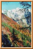 Skuta from Kalce.
This late autumn view shows Kogel, Gamsov skret,
Skuta (2532m)
and the Veliki greben ridge from the path to Kalce and Kalska gora,
a few hundred metres above Kamniska bistrica. The southern slopes
you see in the figure (where the forest is not very dense anymore,
but has not completely given up to the bare rocks) are a safe haven
for wild animals in the winter. Especially at the base of the southern
face of Kogel, where there is a cave in which `gamsi' (?) stay over winter.
In addition, this small southern face with a few ideally positioned
more or less vertical portions (sometimes dry even in winter because
of the constant sunshine) is also very popular among climbers.
Skuta from Kalce.
This late autumn view shows Kogel, Gamsov skret,
Skuta (2532m)
and the Veliki greben ridge from the path to Kalce and Kalska gora,
a few hundred metres above Kamniska bistrica. The southern slopes
you see in the figure (where the forest is not very dense anymore,
but has not completely given up to the bare rocks) are a safe haven
for wild animals in the winter. Especially at the base of the southern
face of Kogel, where there is a cave in which `gamsi' (?) stay over winter.
In addition, this small southern face with a few ideally positioned
more or less vertical portions (sometimes dry even in winter because
of the constant sunshine) is also very popular among climbers.
|
 Kalski greben from Presedlaj.
This late autumn photo shows the
westernmost part of Kamniske Alpe
as seen from the saddle point of Presedlaj (1613m). The mountains on
the left are Mokrica (1853m), Kompotela (1989m) and Vrh korena (1999m),
and in the middle of the photo Kalski greben (2224m) and Kalska gora (2058m).
The lowest point in the ridge, just where the pyramid of Grintovec (2558m)
starts to rise, is the Kokrsko sedlo (1791m). This point (`sedlo' means
`saddle') is a very peculiar passage from the valley of the small rivers
Kamniska bistrica on the east (this side of the ridge shown) and of the
Kokra on the west (other side of the ridge). The ascent from the west is
scented by rocks and walls above your head and cast into deep snow and
hard ice during the winter; the ascent from the west is much friendlier,
especially in the summer: the beautiful meadows and pastures
owned by an old native, Suhadolnik, take you to the saddle before
you could say `cookie'.
Kalski greben from Presedlaj.
This late autumn photo shows the
westernmost part of Kamniske Alpe
as seen from the saddle point of Presedlaj (1613m). The mountains on
the left are Mokrica (1853m), Kompotela (1989m) and Vrh korena (1999m),
and in the middle of the photo Kalski greben (2224m) and Kalska gora (2058m).
The lowest point in the ridge, just where the pyramid of Grintovec (2558m)
starts to rise, is the Kokrsko sedlo (1791m). This point (`sedlo' means
`saddle') is a very peculiar passage from the valley of the small rivers
Kamniska bistrica on the east (this side of the ridge shown) and of the
Kokra on the west (other side of the ridge). The ascent from the west is
scented by rocks and walls above your head and cast into deep snow and
hard ice during the winter; the ascent from the west is much friendlier,
especially in the summer: the beautiful meadows and pastures
owned by an old native, Suhadolnik, take you to the saddle before
you could say `cookie'.
 Brana and Kamnisko sedlo from Planjava.
Another, probably the most famous mountain
saddle in Slovenia, is the
Kamnisko sedlo (1884m), also called The Jerman's Door. The most popular
path to it leads from Kamniska bistrica in the south past Pastirci (1420m).
The protruding rocks at the bottom of the zig-zaggy path are just
about half-way from Pastirci to the saddle; when you're tired (say, in
the merciless summer sun which shines directly into your neck) or when
you're half lost in the winter mist, these rocks are a useful checkpoint.
But the real fun starts at the saddle, not below it. The Jerman's Door
is namely a good starting point for the whole area of Grintovci,
the mountain group named after Grintovec (2558m), its highest peak.
On the photo, from the left: Brana (2253m), the Jerman's Door's
`local' peak (but beware its treacherous northern slopes in winter
-- they end up smoothly somewhere half a mile below), Skuta (2532m),
and three Rinke. On the extreme right, the crumbly Mrzli vrh (2094m)
and Mrzla gora (2203m).
Brana and Kamnisko sedlo from Planjava.
Another, probably the most famous mountain
saddle in Slovenia, is the
Kamnisko sedlo (1884m), also called The Jerman's Door. The most popular
path to it leads from Kamniska bistrica in the south past Pastirci (1420m).
The protruding rocks at the bottom of the zig-zaggy path are just
about half-way from Pastirci to the saddle; when you're tired (say, in
the merciless summer sun which shines directly into your neck) or when
you're half lost in the winter mist, these rocks are a useful checkpoint.
But the real fun starts at the saddle, not below it. The Jerman's Door
is namely a good starting point for the whole area of Grintovci,
the mountain group named after Grintovec (2558m), its highest peak.
On the photo, from the left: Brana (2253m), the Jerman's Door's
`local' peak (but beware its treacherous northern slopes in winter
-- they end up smoothly somewhere half a mile below), Skuta (2532m),
and three Rinke. On the extreme right, the crumbly Mrzli vrh (2094m)
and Mrzla gora (2203m).
 Kalska gora and Kalski greben from Podi.
Kalska gora (left, 2058m) and Kalski greben
(2224m, right) are here seen
from the small plateau of Podi just below the top pyramid of Grintovec
(2558m). This is a late summer photo and the sun is just rising so that
the ridge is lit from the east. The western face oversees the Kokra valley
and the pleasant Suhi dol (the grassy slopes above the Suhadolnik's
farm, which can also be reached through an unpaved road from Kokra).
At the end of the ridge, at the extreme left and down, is the Kokrsko sedlo
with a mountain hut (1791m), a standard resting place on your way to either
the top of Kalska gora and Kalski greben or on your way to Grintovec.
If you follow the ridge towards the south, it will eventually bring you
to Koren, Kompotela and Mokrica, the last significant stretches of
Kamniske alpe to the south. But even as an individual goal, these two
(slightly off-the-beaten-track) mountains are a real pleasure.
Kalska gora and Kalski greben from Podi.
Kalska gora (left, 2058m) and Kalski greben
(2224m, right) are here seen
from the small plateau of Podi just below the top pyramid of Grintovec
(2558m). This is a late summer photo and the sun is just rising so that
the ridge is lit from the east. The western face oversees the Kokra valley
and the pleasant Suhi dol (the grassy slopes above the Suhadolnik's
farm, which can also be reached through an unpaved road from Kokra).
At the end of the ridge, at the extreme left and down, is the Kokrsko sedlo
with a mountain hut (1791m), a standard resting place on your way to either
the top of Kalska gora and Kalski greben or on your way to Grintovec.
If you follow the ridge towards the south, it will eventually bring you
to Koren, Kompotela and Mokrica, the last significant stretches of
Kamniske alpe to the south. But even as an individual goal, these two
(slightly off-the-beaten-track) mountains are a real pleasure.
 Grintovci from the south.
An overall, early spring view of
Grintovci from the Sava valley.
From the left, Kocna (2540m) and Grintovec (2558m). Some people
tend to misidentify the saddle between them as Kamnisko sedlo
(Jerman's Door). It is a saddle indeed, but it is called Mlinarsko sedlo
and is more difficult to reach. Next comes Kalski greben with its
characteristic, slow rise, and at the end, the rounded Krvavec (1853m),
which is a big ski resort, and an almost compulsory meeting-point
for skiing enthusiasts from Kranj, Ljubljana and whole Slovenia.
A very popular thing to hear in Ljubljana's offices (but don't tell
it to anyone) at 11 AM: ``Let's go on the afternoon's''
(meaning: let's go to ski on Krvavec from 12 AM to 4 PM; work can wait).
Grintovci from the south.
An overall, early spring view of
Grintovci from the Sava valley.
From the left, Kocna (2540m) and Grintovec (2558m). Some people
tend to misidentify the saddle between them as Kamnisko sedlo
(Jerman's Door). It is a saddle indeed, but it is called Mlinarsko sedlo
and is more difficult to reach. Next comes Kalski greben with its
characteristic, slow rise, and at the end, the rounded Krvavec (1853m),
which is a big ski resort, and an almost compulsory meeting-point
for skiing enthusiasts from Kranj, Ljubljana and whole Slovenia.
A very popular thing to hear in Ljubljana's offices (but don't tell
it to anyone) at 11 AM: ``Let's go on the afternoon's''
(meaning: let's go to ski on Krvavec from 12 AM to 4 PM; work can wait).
 Grintovec from Skuta.
A very instructive, high-summer view from Skuta (2532m),
one of the central peaks of the Grintovci group, to the west.
There are many interesting features to be seen here: first, the challenging
pyramid of Grintovec (its southwestern side, which is hidden behind the
edge, is also called `the roof') looks fine now, but becomes more
dangerous and tricky in winter. To the right is the peak of Kocna (2540m);
the peaks are connected through the Mlinarsko sedlo. In the far background,
Julijske alpe with Triglav (2864m). Two cool things in the foreground:
the red colour of the rocks in the lower left corner of the photo
means that they contain iron in abundance (beware in case of lighting!);
the big oblique rock in the centre of the photo looks like
a piece of rock from above, but from below, it in fact gives an
impression of a real peak. It is called Struca (2457m) and
it resembles a loaf of bread from if viewed from any direction.
Indeed, `struca' means `loaf'.
Grintovec from Skuta.
A very instructive, high-summer view from Skuta (2532m),
one of the central peaks of the Grintovci group, to the west.
There are many interesting features to be seen here: first, the challenging
pyramid of Grintovec (its southwestern side, which is hidden behind the
edge, is also called `the roof') looks fine now, but becomes more
dangerous and tricky in winter. To the right is the peak of Kocna (2540m);
the peaks are connected through the Mlinarsko sedlo. In the far background,
Julijske alpe with Triglav (2864m). Two cool things in the foreground:
the red colour of the rocks in the lower left corner of the photo
means that they contain iron in abundance (beware in case of lighting!);
the big oblique rock in the centre of the photo looks like
a piece of rock from above, but from below, it in fact gives an
impression of a real peak. It is called Struca (2457m) and
it resembles a loaf of bread from if viewed from any direction.
Indeed, `struca' means `loaf'.
 Storzic from Krvavec.
Remember the fog above the Sava river valley
I mentioned in the page
about Karavanke? This is how it looks like in winter when
the temperature inversion keeping the cold air close to the ground
and warm air at altitudes above 500, 600 metres or so, can persist
for days or even weeks. This evening photo was taken from Krvavec,
the popular ski resort at the northeastern edge of the Sava river valley,
about 35 kilometres from Ljubljana. Far behind is Storzic (2132m)
with Srednji vrh in the front. Observe the low clouds how they
spill over the ridges.
Storzic from Krvavec.
Remember the fog above the Sava river valley
I mentioned in the page
about Karavanke? This is how it looks like in winter when
the temperature inversion keeping the cold air close to the ground
and warm air at altitudes above 500, 600 metres or so, can persist
for days or even weeks. This evening photo was taken from Krvavec,
the popular ski resort at the northeastern edge of the Sava river valley,
about 35 kilometres from Ljubljana. Far behind is Storzic (2132m)
with Srednji vrh in the front. Observe the low clouds how they
spill over the ridges.
 Velika planina.
Velika planina is an alpine `Alm',
and is in fact a plateau stretched
over a few kilometres at an altitude of about 1500 metres. It is
similarly close to Ljubljana, about 30 kilometres or so, and is a
popular sunday `stroll' for many families and non-demanding hikers.
There's also a cable car that takes you here in five minutes,
but the path over St. Jacob is worth trying since it can offer many
divertions and surprises in all seasons. At the plateau, there is
a small settlement of very interesting traditionally designed
shepherds' cottages (some of them used as weekend houses, but they've
not been by any means transfigured) and a small chapel. This early
spring photo shows the chapel with the view towards the main chain
of Kamniske alpe in the north.
Velika planina.
Velika planina is an alpine `Alm',
and is in fact a plateau stretched
over a few kilometres at an altitude of about 1500 metres. It is
similarly close to Ljubljana, about 30 kilometres or so, and is a
popular sunday `stroll' for many families and non-demanding hikers.
There's also a cable car that takes you here in five minutes,
but the path over St. Jacob is worth trying since it can offer many
divertions and surprises in all seasons. At the plateau, there is
a small settlement of very interesting traditionally designed
shepherds' cottages (some of them used as weekend houses, but they've
not been by any means transfigured) and a small chapel. This early
spring photo shows the chapel with the view towards the main chain
of Kamniske alpe in the north.
 Skuta from Kalce.
This late autumn view shows Kogel, Gamsov skret,
Skuta (2532m)
and the Veliki greben ridge from the path to Kalce and Kalska gora,
a few hundred metres above Kamniska bistrica. The southern slopes
you see in the figure (where the forest is not very dense anymore,
but has not completely given up to the bare rocks) are a safe haven
for wild animals in the winter. Especially at the base of the southern
face of Kogel, where there is a cave in which `gamsi' (?) stay over winter.
In addition, this small southern face with a few ideally positioned
more or less vertical portions (sometimes dry even in winter because
of the constant sunshine) is also very popular among climbers.
Skuta from Kalce.
This late autumn view shows Kogel, Gamsov skret,
Skuta (2532m)
and the Veliki greben ridge from the path to Kalce and Kalska gora,
a few hundred metres above Kamniska bistrica. The southern slopes
you see in the figure (where the forest is not very dense anymore,
but has not completely given up to the bare rocks) are a safe haven
for wild animals in the winter. Especially at the base of the southern
face of Kogel, where there is a cave in which `gamsi' (?) stay over winter.
In addition, this small southern face with a few ideally positioned
more or less vertical portions (sometimes dry even in winter because
of the constant sunshine) is also very popular among climbers.