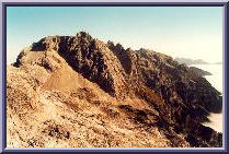
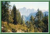
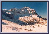
 View from Kriz.
A view from Kriz (2401m) towards the North. Just below the standpoint
is the small plateau Na rusju (about 2000m) with an alpine bivouac Bivak IV
(1980m) somewhere at the left edge of the dark pine trees on the right
side of the picture. The mountain ridge in the middle of the photo
with its south wall cast in shadow is Dolkova spica (2591m), and hides
the south wall of the noble Skrlatica (2740m) of which only the peak is
visible. The three consecutive peaks to its right (to the east) are
the brittle Visoki (2646m), Srednji (2589m) and Spodnji rokav (2500m).
Below, in the autumn morning fog: the Vrata valley. The plateau Na rusju
is known, among other things, for its herds of steinbocks (ibex).
View from Kriz.
A view from Kriz (2401m) towards the North. Just below the standpoint
is the small plateau Na rusju (about 2000m) with an alpine bivouac Bivak IV
(1980m) somewhere at the left edge of the dark pine trees on the right
side of the picture. The mountain ridge in the middle of the photo
with its south wall cast in shadow is Dolkova spica (2591m), and hides
the south wall of the noble Skrlatica (2740m) of which only the peak is
visible. The three consecutive peaks to its right (to the east) are
the brittle Visoki (2646m), Srednji (2589m) and Spodnji rokav (2500m).
Below, in the autumn morning fog: the Vrata valley. The plateau Na rusju
is known, among other things, for its herds of steinbocks (ibex).
|
 Triglav from Dovska vratca.
The Vrata valley
below is covered by a layer of thick mist which can persist for hours
in autumn days when the Sun is not able to dissolve it anymore. You guessed
it, it is late September or early October and this is the time to be here.
As a background to the wandering herds of steinbocks, the ridges of
Cmir (2393m) and Vrbanove spice (2408m, 2299m) with Begunjski vrh (2461m)
to the left, and the dominant feature of the Triglav (2864m) north face
hidden in shadow. The black dot in the open just below the only cumulus
in the photo is the Kredarica mountain hut (2515m). It's not actually
a hut, it's a big thing. The path in the photo comes from Vrata
through Sovatna and leads to Kriski podi, a high plateau with three
small lakes.
Triglav from Dovska vratca.
The Vrata valley
below is covered by a layer of thick mist which can persist for hours
in autumn days when the Sun is not able to dissolve it anymore. You guessed
it, it is late September or early October and this is the time to be here.
As a background to the wandering herds of steinbocks, the ridges of
Cmir (2393m) and Vrbanove spice (2408m, 2299m) with Begunjski vrh (2461m)
to the left, and the dominant feature of the Triglav (2864m) north face
hidden in shadow. The black dot in the open just below the only cumulus
in the photo is the Kredarica mountain hut (2515m). It's not actually
a hut, it's a big thing. The path in the photo comes from Vrata
through Sovatna and leads to Kriski podi, a high plateau with three
small lakes.
|
 Triglav from Planja.
Almost the same view, but from a different
(more distant) place:
the mountaintop of Planja (2447m) above the Kriski podi plateau.
On the left, the ridges of Cmir and Vrbanove spice, far beyond is the
Rjavina (2532m), in the middle the `local' peaks to the Kredarica hut
and to the right, again, Triglav. The tooth in its southern ridge is
the Triglavska skrbina (2659m). In the more brown-yellowish colour tone
in the front are the Bovski gamsovec (2392m) to the left of Triglav
and Pihavec (2414m) to the right.
Triglav from Planja.
Almost the same view, but from a different
(more distant) place:
the mountaintop of Planja (2447m) above the Kriski podi plateau.
On the left, the ridges of Cmir and Vrbanove spice, far beyond is the
Rjavina (2532m), in the middle the `local' peaks to the Kredarica hut
and to the right, again, Triglav. The tooth in its southern ridge is
the Triglavska skrbina (2659m). In the more brown-yellowish colour tone
in the front are the Bovski gamsovec (2392m) to the left of Triglav
and Pihavec (2414m) to the right.
|
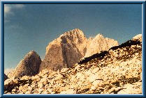 Jalovec from Kotovo sedlo.
Now, this is a famous mountain!
It is so appreciated it even came into
the coat-of-arms of the Slovenian Alpine Federation. The picture was taken
from a small plateau of Kotovo sedlo. The path over its southwestern edge
takes you already to the valley of Koritnica, which is an affluent stream
to the river of Soca. The Soca flows into the Adriatic Sea and its waters
flow into the Mediterranean Sea. From this side of the mountain, all water
finally reaches the Sava river, then Donava, and it all ends up in the
Black Sea. To the left is the Golicica (2394m). The famed shady Jalovec
couloir just below it, which has just been closed for its inherent dangers
of falling stones and icy slope, separates it from the main mass of
Jalovec (2645m). The ascent to Jalovec from Kotovo sedlo goes along
the ridge to the right of the photo.
Jalovec from Kotovo sedlo.
Now, this is a famous mountain!
It is so appreciated it even came into
the coat-of-arms of the Slovenian Alpine Federation. The picture was taken
from a small plateau of Kotovo sedlo. The path over its southwestern edge
takes you already to the valley of Koritnica, which is an affluent stream
to the river of Soca. The Soca flows into the Adriatic Sea and its waters
flow into the Mediterranean Sea. From this side of the mountain, all water
finally reaches the Sava river, then Donava, and it all ends up in the
Black Sea. To the left is the Golicica (2394m). The famed shady Jalovec
couloir just below it, which has just been closed for its inherent dangers
of falling stones and icy slope, separates it from the main mass of
Jalovec (2645m). The ascent to Jalovec from Kotovo sedlo goes along
the ridge to the right of the photo.
|
 Kotova spica from Kotovo sedlo.
Same spot, but a different view (to the north).
The peak to the left
is Kotova spica (2376m), to the right, Vevnica (2340m) and Strmi strug (2265m)
with the beginning of the Ponce ridge following the north-south direction
high above the Tamar (Planica) valley. The ridge on the right part
of the photo is the border to Italy and behind it is the beautiful
valley of the Belopeska lakes. But on this side, the time to be here
is when the snow conditions are good: skiing from Kotovo sedlo
into the Tamar valley is a classic. But before embarking on a downhill,
check the weather forecast and the avalanche warnings!
Kotova spica from Kotovo sedlo.
Same spot, but a different view (to the north).
The peak to the left
is Kotova spica (2376m), to the right, Vevnica (2340m) and Strmi strug (2265m)
with the beginning of the Ponce ridge following the north-south direction
high above the Tamar (Planica) valley. The ridge on the right part
of the photo is the border to Italy and behind it is the beautiful
valley of the Belopeska lakes. But on this side, the time to be here
is when the snow conditions are good: skiing from Kotovo sedlo
into the Tamar valley is a classic. But before embarking on a downhill,
check the weather forecast and the avalanche warnings!
|
 Bavski Grintavec from Zadnja Trenta.
The last, most secluded portion of
the Trenta valley ends up here,
in the calm meadows surrounded by Skutnik (2172m) and the chain of
Pelci to the right and Srebrnjak (2100m) and Trentski pelc (2109m) to the left.
The scene is dominated by the massive Bavski grintavec (2347m) in the middle.
There's something for everyone to see on this mountain: archaic views like
this from the Zadnja Trenta (from the northeast), rarely trodden, secluded
hiking paths from the small valleys of Bavsica and Bala (from the west
and north), as well as rich flora and myriads of snakes along the path
from the Soca village (from the south, from the left on the photo).
The time to be here: late spring and early summer when rather steep and hot
ascents are not all too hot.
Bavski Grintavec from Zadnja Trenta.
The last, most secluded portion of
the Trenta valley ends up here,
in the calm meadows surrounded by Skutnik (2172m) and the chain of
Pelci to the right and Srebrnjak (2100m) and Trentski pelc (2109m) to the left.
The scene is dominated by the massive Bavski grintavec (2347m) in the middle.
There's something for everyone to see on this mountain: archaic views like
this from the Zadnja Trenta (from the northeast), rarely trodden, secluded
hiking paths from the small valleys of Bavsica and Bala (from the west
and north), as well as rich flora and myriads of snakes along the path
from the Soca village (from the south, from the left on the photo).
The time to be here: late spring and early summer when rather steep and hot
ascents are not all too hot.
|
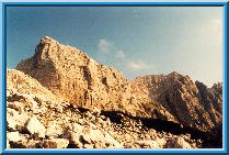
 Skrlatica from Ovcja stran.
This photo shows a magnificent view from
a seemingly rather insignificant
mountain of Ovcja stran above the valley of Tamar. Only a non-marked
path is leading up here (a bit difficult to trace on occasions)
which is a part of a much longer path traversing the northern faces
of some of the Julian Alps starting in Planica and ending on Pokljuka.
This path, called `PP' for its starting and end points, was `designed'
a decade ago by alpine climbers U. Zupancic and D. Vodeb, and is
primarily meant to be used by experienced hikers, ex-climbers,
and soloists of all sorts. The nice looks can be deceiving, however,
since this path sometimes passes through pretty harsh high-mountain
world, and many times it's better to watch your step (and grip!)
than watch around.
Skrlatica from Ovcja stran.
This photo shows a magnificent view from
a seemingly rather insignificant
mountain of Ovcja stran above the valley of Tamar. Only a non-marked
path is leading up here (a bit difficult to trace on occasions)
which is a part of a much longer path traversing the northern faces
of some of the Julian Alps starting in Planica and ending on Pokljuka.
This path, called `PP' for its starting and end points, was `designed'
a decade ago by alpine climbers U. Zupancic and D. Vodeb, and is
primarily meant to be used by experienced hikers, ex-climbers,
and soloists of all sorts. The nice looks can be deceiving, however,
since this path sometimes passes through pretty harsh high-mountain
world, and many times it's better to watch your step (and grip!)
than watch around.
|
 Zelenci.
Apart from falling into one of these chilly ponds
in the figure, nothing can happen to you around here. These little ponds,
known as Zelenci (== something like `the green ones' in translation),
are in fact the source of the Sava river. The water comes somehow
bubbling from underneath, I don't know exactly how, but the small
volcano-like mounds on the ponds' bottoms are worth spending a few
minutes here (if it weren't for the mosquitos, you would want to
stay longer). Today, this small piece of land is a protected area,
but in the immediate vicinity, there are already ski-lifts of
Podkoren (where the World Cup slalom is held annually, usually in
January) and some houses. But that still somehow does not spoil
the pleasure if you concentrate on what you see. I can still
recall that years ago this place was intact, but even today,
I love to drop around for a visit.
Zelenci.
Apart from falling into one of these chilly ponds
in the figure, nothing can happen to you around here. These little ponds,
known as Zelenci (== something like `the green ones' in translation),
are in fact the source of the Sava river. The water comes somehow
bubbling from underneath, I don't know exactly how, but the small
volcano-like mounds on the ponds' bottoms are worth spending a few
minutes here (if it weren't for the mosquitos, you would want to
stay longer). Today, this small piece of land is a protected area,
but in the immediate vicinity, there are already ski-lifts of
Podkoren (where the World Cup slalom is held annually, usually in
January) and some houses. But that still somehow does not spoil
the pleasure if you concentrate on what you see. I can still
recall that years ago this place was intact, but even today,
I love to drop around for a visit.
|
 Sleme from Ponce.
This magnificent view of Sleme above
the valley of Tamar was
photographed from the path leading to Visoka Ponca and to the ridge
of other *Ponca peaks. At least in the lower portions of the
path, one can enjoy the views without heeding too much care to
the abyss below. In late autumn, the view of Skrlatica (2738m)
at the left in the background is intensified, not obscured,
by the golden-yellow trees (I have to look up their English name
in the dictionary) in the foreground. At the right side are the
serious northern faces of Mojstrovka, Site and Travnik, a paradise
for alpine climbers of routes of a few 100 metres in all grades.
In the middle of the photo, the parabola-shaped easy-does-it
mountain of Sleme, one of the most famous, most enjoyable and
most talked about spots to offer the view of Jalovec (2647m)
that closes the valley.
Sleme from Ponce.
This magnificent view of Sleme above
the valley of Tamar was
photographed from the path leading to Visoka Ponca and to the ridge
of other *Ponca peaks. At least in the lower portions of the
path, one can enjoy the views without heeding too much care to
the abyss below. In late autumn, the view of Skrlatica (2738m)
at the left in the background is intensified, not obscured,
by the golden-yellow trees (I have to look up their English name
in the dictionary) in the foreground. At the right side are the
serious northern faces of Mojstrovka, Site and Travnik, a paradise
for alpine climbers of routes of a few 100 metres in all grades.
In the middle of the photo, the parabola-shaped easy-does-it
mountain of Sleme, one of the most famous, most enjoyable and
most talked about spots to offer the view of Jalovec (2647m)
that closes the valley.
|
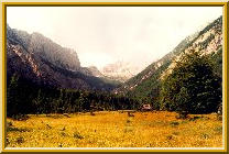
 Planina Javornik on Pokljuka.
A calm and somehow always sunlit Alm in
the heart of the Pokljuka
plateau. In its vicinity is the Sport Hotel where you can leave
your car; within an hour or two, you can easily enjoy the view
of the two white peaks here only seen in the distant background.
The left one is in fact Triglav (2864m), our highest peak.
The three peaks in the foreground (Visevnik and Draski vrh) are
ideal spots for winter off-track skiing, if you don't mind the
flocks of people that gather there on sunny winter or early spring days.
Planina Javornik on Pokljuka.
A calm and somehow always sunlit Alm in
the heart of the Pokljuka
plateau. In its vicinity is the Sport Hotel where you can leave
your car; within an hour or two, you can easily enjoy the view
of the two white peaks here only seen in the distant background.
The left one is in fact Triglav (2864m), our highest peak.
The three peaks in the foreground (Visevnik and Draski vrh) are
ideal spots for winter off-track skiing, if you don't mind the
flocks of people that gather there on sunny winter or early spring days.
|
 Triglav from Staniceva koca.
This view of Triglav was
photographed from the mountain hut
named after Valentin Stanic, one of the first serious hikers in this
region, meaning that he was among the first that `walked' around
unaided by a local guide. The hut lies on the eastern side of the
mountain, and what you see here on the slopes just under the
line where the shadow ends, are the remnants of a past ice-age
glacier, now almost completely retreated in less than a century.
The tectonic activities were radical around here, and the whole
region we enjoy now so much, was once submerged, believe it
or not, by the Pannonian sea. The mountains rose themselves as well,
of course, but the fact is that you can found fossils at the top
of mountains of 2000 metres altitude or more! There is one more
awe-inspiring fact that remains hidden in this photo: the Triglav
north face, starting at the right edge of the photo where your head
starts to spin, a 3 kilometres long and 1 kilometer high wall of limestone,
another climber's paradise. You must see it from the Vrata valley.
Triglav from Staniceva koca.
This view of Triglav was
photographed from the mountain hut
named after Valentin Stanic, one of the first serious hikers in this
region, meaning that he was among the first that `walked' around
unaided by a local guide. The hut lies on the eastern side of the
mountain, and what you see here on the slopes just under the
line where the shadow ends, are the remnants of a past ice-age
glacier, now almost completely retreated in less than a century.
The tectonic activities were radical around here, and the whole
region we enjoy now so much, was once submerged, believe it
or not, by the Pannonian sea. The mountains rose themselves as well,
of course, but the fact is that you can found fossils at the top
of mountains of 2000 metres altitude or more! There is one more
awe-inspiring fact that remains hidden in this photo: the Triglav
north face, starting at the right edge of the photo where your head
starts to spin, a 3 kilometres long and 1 kilometer high wall of limestone,
another climber's paradise. You must see it from the Vrata valley.
|
 Planina Ovcarija.
A bit farther south, a bit more relaxing
view of the Spodnje bohinsjke gore, a mountain ridge ending up
the Julian Alps in the south.
The snowy alm in the foreground is Planina Ovcarija, once a prospering
shepherds' cottage village, producing milk, cheese and other milk
products in abundance, now abandoned by shepherds and invaded by
hikers heading for the Triglav lakes. There are not that many
in winter, though, and such calm and fresh views can easily be
enjoyed without being disturbed.
Planina Ovcarija.
A bit farther south, a bit more relaxing
view of the Spodnje bohinsjke gore, a mountain ridge ending up
the Julian Alps in the south.
The snowy alm in the foreground is Planina Ovcarija, once a prospering
shepherds' cottage village, producing milk, cheese and other milk
products in abundance, now abandoned by shepherds and invaded by
hikers heading for the Triglav lakes. There are not that many
in winter, though, and such calm and fresh views can easily be
enjoyed without being disturbed.
|
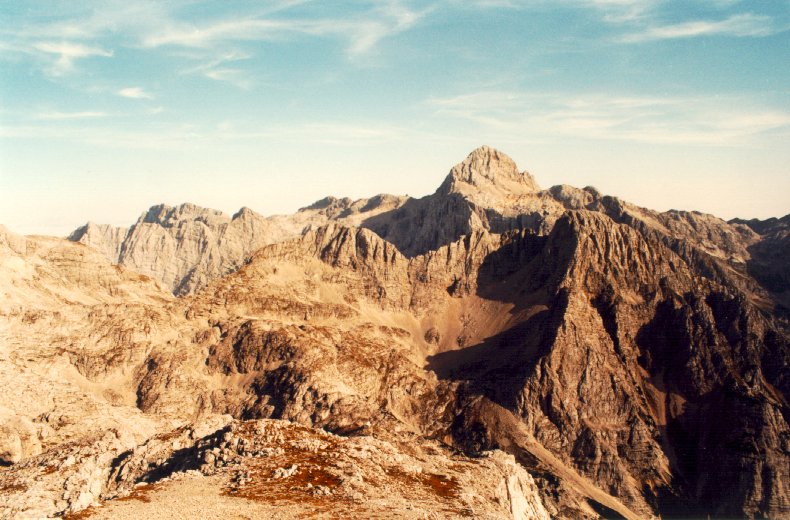
 The ridge of Ticarica.
The ridge of Ticarica and Zelnarica,
with four peaks around 2200
or 2300 metres altitude, is a delimiter between the valley of the
seven Triglav lakes and the eastern portion of the Julian Alps,
and is actually rarely visited. The main stream of hikers use
the path at the bottom of the valley, at the right side of the ridge
on this photo. The eastern side (here to the left) is not as
steep as the western side (underneath, there is a mountain hut
at the 3rd and the 4th Triglav lake (which
actually form one single lake -- you might call them ponds
since they're really small, but we call them that way).
In summer, climbing upwards from the hut below right and reaching
the plateau on the left, you might have to fight your way up between
the cows that will watch your progress.
The ridge of Ticarica.
The ridge of Ticarica and Zelnarica,
with four peaks around 2200
or 2300 metres altitude, is a delimiter between the valley of the
seven Triglav lakes and the eastern portion of the Julian Alps,
and is actually rarely visited. The main stream of hikers use
the path at the bottom of the valley, at the right side of the ridge
on this photo. The eastern side (here to the left) is not as
steep as the western side (underneath, there is a mountain hut
at the 3rd and the 4th Triglav lake (which
actually form one single lake -- you might call them ponds
since they're really small, but we call them that way).
In summer, climbing upwards from the hut below right and reaching
the plateau on the left, you might have to fight your way up between
the cows that will watch your progress.
|
 View from Kriz.
A view from Kriz (2401m) towards the North. Just below the standpoint
is the small plateau Na rusju (about 2000m) with an alpine bivouac Bivak IV
(1980m) somewhere at the left edge of the dark pine trees on the right
side of the picture. The mountain ridge in the middle of the photo
with its south wall cast in shadow is Dolkova spica (2591m), and hides
the south wall of the noble Skrlatica (2740m) of which only the peak is
visible. The three consecutive peaks to its right (to the east) are
the brittle Visoki (2646m), Srednji (2589m) and Spodnji rokav (2500m).
Below, in the autumn morning fog: the Vrata valley. The plateau Na rusju
is known, among other things, for its herds of steinbocks (ibex).
View from Kriz.
A view from Kriz (2401m) towards the North. Just below the standpoint
is the small plateau Na rusju (about 2000m) with an alpine bivouac Bivak IV
(1980m) somewhere at the left edge of the dark pine trees on the right
side of the picture. The mountain ridge in the middle of the photo
with its south wall cast in shadow is Dolkova spica (2591m), and hides
the south wall of the noble Skrlatica (2740m) of which only the peak is
visible. The three consecutive peaks to its right (to the east) are
the brittle Visoki (2646m), Srednji (2589m) and Spodnji rokav (2500m).
Below, in the autumn morning fog: the Vrata valley. The plateau Na rusju
is known, among other things, for its herds of steinbocks (ibex).
 Triglav from Dovska vratca.
The Vrata valley
below is covered by a layer of thick mist which can persist for hours
in autumn days when the Sun is not able to dissolve it anymore. You guessed
it, it is late September or early October and this is the time to be here.
As a background to the wandering herds of steinbocks, the ridges of
Cmir (2393m) and Vrbanove spice (2408m, 2299m) with Begunjski vrh (2461m)
to the left, and the dominant feature of the Triglav (2864m) north face
hidden in shadow. The black dot in the open just below the only cumulus
in the photo is the Kredarica mountain hut (2515m). It's not actually
a hut, it's a big thing. The path in the photo comes from Vrata
through Sovatna and leads to Kriski podi, a high plateau with three
small lakes.
Triglav from Dovska vratca.
The Vrata valley
below is covered by a layer of thick mist which can persist for hours
in autumn days when the Sun is not able to dissolve it anymore. You guessed
it, it is late September or early October and this is the time to be here.
As a background to the wandering herds of steinbocks, the ridges of
Cmir (2393m) and Vrbanove spice (2408m, 2299m) with Begunjski vrh (2461m)
to the left, and the dominant feature of the Triglav (2864m) north face
hidden in shadow. The black dot in the open just below the only cumulus
in the photo is the Kredarica mountain hut (2515m). It's not actually
a hut, it's a big thing. The path in the photo comes from Vrata
through Sovatna and leads to Kriski podi, a high plateau with three
small lakes.
 Triglav from Planja.
Almost the same view, but from a different
(more distant) place:
the mountaintop of Planja (2447m) above the Kriski podi plateau.
On the left, the ridges of Cmir and Vrbanove spice, far beyond is the
Rjavina (2532m), in the middle the `local' peaks to the Kredarica hut
and to the right, again, Triglav. The tooth in its southern ridge is
the Triglavska skrbina (2659m). In the more brown-yellowish colour tone
in the front are the Bovski gamsovec (2392m) to the left of Triglav
and Pihavec (2414m) to the right.
Triglav from Planja.
Almost the same view, but from a different
(more distant) place:
the mountaintop of Planja (2447m) above the Kriski podi plateau.
On the left, the ridges of Cmir and Vrbanove spice, far beyond is the
Rjavina (2532m), in the middle the `local' peaks to the Kredarica hut
and to the right, again, Triglav. The tooth in its southern ridge is
the Triglavska skrbina (2659m). In the more brown-yellowish colour tone
in the front are the Bovski gamsovec (2392m) to the left of Triglav
and Pihavec (2414m) to the right.
 Jalovec from Kotovo sedlo.
Now, this is a famous mountain!
It is so appreciated it even came into
the coat-of-arms of the Slovenian Alpine Federation. The picture was taken
from a small plateau of Kotovo sedlo. The path over its southwestern edge
takes you already to the valley of Koritnica, which is an affluent stream
to the river of Soca. The Soca flows into the Adriatic Sea and its waters
flow into the Mediterranean Sea. From this side of the mountain, all water
finally reaches the Sava river, then Donava, and it all ends up in the
Black Sea. To the left is the Golicica (2394m). The famed shady Jalovec
couloir just below it, which has just been closed for its inherent dangers
of falling stones and icy slope, separates it from the main mass of
Jalovec (2645m). The ascent to Jalovec from Kotovo sedlo goes along
the ridge to the right of the photo.
Jalovec from Kotovo sedlo.
Now, this is a famous mountain!
It is so appreciated it even came into
the coat-of-arms of the Slovenian Alpine Federation. The picture was taken
from a small plateau of Kotovo sedlo. The path over its southwestern edge
takes you already to the valley of Koritnica, which is an affluent stream
to the river of Soca. The Soca flows into the Adriatic Sea and its waters
flow into the Mediterranean Sea. From this side of the mountain, all water
finally reaches the Sava river, then Donava, and it all ends up in the
Black Sea. To the left is the Golicica (2394m). The famed shady Jalovec
couloir just below it, which has just been closed for its inherent dangers
of falling stones and icy slope, separates it from the main mass of
Jalovec (2645m). The ascent to Jalovec from Kotovo sedlo goes along
the ridge to the right of the photo.
 Kotova spica from Kotovo sedlo.
Same spot, but a different view (to the north).
The peak to the left
is Kotova spica (2376m), to the right, Vevnica (2340m) and Strmi strug (2265m)
with the beginning of the Ponce ridge following the north-south direction
high above the Tamar (Planica) valley. The ridge on the right part
of the photo is the border to Italy and behind it is the beautiful
valley of the Belopeska lakes. But on this side, the time to be here
is when the snow conditions are good: skiing from Kotovo sedlo
into the Tamar valley is a classic. But before embarking on a downhill,
check the weather forecast and the avalanche warnings!
Kotova spica from Kotovo sedlo.
Same spot, but a different view (to the north).
The peak to the left
is Kotova spica (2376m), to the right, Vevnica (2340m) and Strmi strug (2265m)
with the beginning of the Ponce ridge following the north-south direction
high above the Tamar (Planica) valley. The ridge on the right part
of the photo is the border to Italy and behind it is the beautiful
valley of the Belopeska lakes. But on this side, the time to be here
is when the snow conditions are good: skiing from Kotovo sedlo
into the Tamar valley is a classic. But before embarking on a downhill,
check the weather forecast and the avalanche warnings!
 Bavski Grintavec from Zadnja Trenta.
The last, most secluded portion of
the Trenta valley ends up here,
in the calm meadows surrounded by Skutnik (2172m) and the chain of
Pelci to the right and Srebrnjak (2100m) and Trentski pelc (2109m) to the left.
The scene is dominated by the massive Bavski grintavec (2347m) in the middle.
There's something for everyone to see on this mountain: archaic views like
this from the Zadnja Trenta (from the northeast), rarely trodden, secluded
hiking paths from the small valleys of Bavsica and Bala (from the west
and north), as well as rich flora and myriads of snakes along the path
from the Soca village (from the south, from the left on the photo).
The time to be here: late spring and early summer when rather steep and hot
ascents are not all too hot.
Bavski Grintavec from Zadnja Trenta.
The last, most secluded portion of
the Trenta valley ends up here,
in the calm meadows surrounded by Skutnik (2172m) and the chain of
Pelci to the right and Srebrnjak (2100m) and Trentski pelc (2109m) to the left.
The scene is dominated by the massive Bavski grintavec (2347m) in the middle.
There's something for everyone to see on this mountain: archaic views like
this from the Zadnja Trenta (from the northeast), rarely trodden, secluded
hiking paths from the small valleys of Bavsica and Bala (from the west
and north), as well as rich flora and myriads of snakes along the path
from the Soca village (from the south, from the left on the photo).
The time to be here: late spring and early summer when rather steep and hot
ascents are not all too hot.
 Skrlatica from Ovcja stran.
This photo shows a magnificent view from
a seemingly rather insignificant
mountain of Ovcja stran above the valley of Tamar. Only a non-marked
path is leading up here (a bit difficult to trace on occasions)
which is a part of a much longer path traversing the northern faces
of some of the Julian Alps starting in Planica and ending on Pokljuka.
This path, called `PP' for its starting and end points, was `designed'
a decade ago by alpine climbers U. Zupancic and D. Vodeb, and is
primarily meant to be used by experienced hikers, ex-climbers,
and soloists of all sorts. The nice looks can be deceiving, however,
since this path sometimes passes through pretty harsh high-mountain
world, and many times it's better to watch your step (and grip!)
than watch around.
Skrlatica from Ovcja stran.
This photo shows a magnificent view from
a seemingly rather insignificant
mountain of Ovcja stran above the valley of Tamar. Only a non-marked
path is leading up here (a bit difficult to trace on occasions)
which is a part of a much longer path traversing the northern faces
of some of the Julian Alps starting in Planica and ending on Pokljuka.
This path, called `PP' for its starting and end points, was `designed'
a decade ago by alpine climbers U. Zupancic and D. Vodeb, and is
primarily meant to be used by experienced hikers, ex-climbers,
and soloists of all sorts. The nice looks can be deceiving, however,
since this path sometimes passes through pretty harsh high-mountain
world, and many times it's better to watch your step (and grip!)
than watch around.
 Zelenci.
Apart from falling into one of these chilly ponds
in the figure, nothing can happen to you around here. These little ponds,
known as Zelenci (== something like `the green ones' in translation),
are in fact the source of the Sava river. The water comes somehow
bubbling from underneath, I don't know exactly how, but the small
volcano-like mounds on the ponds' bottoms are worth spending a few
minutes here (if it weren't for the mosquitos, you would want to
stay longer). Today, this small piece of land is a protected area,
but in the immediate vicinity, there are already ski-lifts of
Podkoren (where the World Cup slalom is held annually, usually in
January) and some houses. But that still somehow does not spoil
the pleasure if you concentrate on what you see. I can still
recall that years ago this place was intact, but even today,
I love to drop around for a visit.
Zelenci.
Apart from falling into one of these chilly ponds
in the figure, nothing can happen to you around here. These little ponds,
known as Zelenci (== something like `the green ones' in translation),
are in fact the source of the Sava river. The water comes somehow
bubbling from underneath, I don't know exactly how, but the small
volcano-like mounds on the ponds' bottoms are worth spending a few
minutes here (if it weren't for the mosquitos, you would want to
stay longer). Today, this small piece of land is a protected area,
but in the immediate vicinity, there are already ski-lifts of
Podkoren (where the World Cup slalom is held annually, usually in
January) and some houses. But that still somehow does not spoil
the pleasure if you concentrate on what you see. I can still
recall that years ago this place was intact, but even today,
I love to drop around for a visit.
 Sleme from Ponce.
This magnificent view of Sleme above
the valley of Tamar was
photographed from the path leading to Visoka Ponca and to the ridge
of other *Ponca peaks. At least in the lower portions of the
path, one can enjoy the views without heeding too much care to
the abyss below. In late autumn, the view of Skrlatica (2738m)
at the left in the background is intensified, not obscured,
by the golden-yellow trees (I have to look up their English name
in the dictionary) in the foreground. At the right side are the
serious northern faces of Mojstrovka, Site and Travnik, a paradise
for alpine climbers of routes of a few 100 metres in all grades.
In the middle of the photo, the parabola-shaped easy-does-it
mountain of Sleme, one of the most famous, most enjoyable and
most talked about spots to offer the view of Jalovec (2647m)
that closes the valley.
Sleme from Ponce.
This magnificent view of Sleme above
the valley of Tamar was
photographed from the path leading to Visoka Ponca and to the ridge
of other *Ponca peaks. At least in the lower portions of the
path, one can enjoy the views without heeding too much care to
the abyss below. In late autumn, the view of Skrlatica (2738m)
at the left in the background is intensified, not obscured,
by the golden-yellow trees (I have to look up their English name
in the dictionary) in the foreground. At the right side are the
serious northern faces of Mojstrovka, Site and Travnik, a paradise
for alpine climbers of routes of a few 100 metres in all grades.
In the middle of the photo, the parabola-shaped easy-does-it
mountain of Sleme, one of the most famous, most enjoyable and
most talked about spots to offer the view of Jalovec (2647m)
that closes the valley.
 Planina Javornik on Pokljuka.
A calm and somehow always sunlit Alm in
the heart of the Pokljuka
plateau. In its vicinity is the Sport Hotel where you can leave
your car; within an hour or two, you can easily enjoy the view
of the two white peaks here only seen in the distant background.
The left one is in fact Triglav (2864m), our highest peak.
The three peaks in the foreground (Visevnik and Draski vrh) are
ideal spots for winter off-track skiing, if you don't mind the
flocks of people that gather there on sunny winter or early spring days.
Planina Javornik on Pokljuka.
A calm and somehow always sunlit Alm in
the heart of the Pokljuka
plateau. In its vicinity is the Sport Hotel where you can leave
your car; within an hour or two, you can easily enjoy the view
of the two white peaks here only seen in the distant background.
The left one is in fact Triglav (2864m), our highest peak.
The three peaks in the foreground (Visevnik and Draski vrh) are
ideal spots for winter off-track skiing, if you don't mind the
flocks of people that gather there on sunny winter or early spring days.
 Triglav from Staniceva koca.
This view of Triglav was
photographed from the mountain hut
named after Valentin Stanic, one of the first serious hikers in this
region, meaning that he was among the first that `walked' around
unaided by a local guide. The hut lies on the eastern side of the
mountain, and what you see here on the slopes just under the
line where the shadow ends, are the remnants of a past ice-age
glacier, now almost completely retreated in less than a century.
The tectonic activities were radical around here, and the whole
region we enjoy now so much, was once submerged, believe it
or not, by the Pannonian sea. The mountains rose themselves as well,
of course, but the fact is that you can found fossils at the top
of mountains of 2000 metres altitude or more! There is one more
awe-inspiring fact that remains hidden in this photo: the Triglav
north face, starting at the right edge of the photo where your head
starts to spin, a 3 kilometres long and 1 kilometer high wall of limestone,
another climber's paradise. You must see it from the Vrata valley.
Triglav from Staniceva koca.
This view of Triglav was
photographed from the mountain hut
named after Valentin Stanic, one of the first serious hikers in this
region, meaning that he was among the first that `walked' around
unaided by a local guide. The hut lies on the eastern side of the
mountain, and what you see here on the slopes just under the
line where the shadow ends, are the remnants of a past ice-age
glacier, now almost completely retreated in less than a century.
The tectonic activities were radical around here, and the whole
region we enjoy now so much, was once submerged, believe it
or not, by the Pannonian sea. The mountains rose themselves as well,
of course, but the fact is that you can found fossils at the top
of mountains of 2000 metres altitude or more! There is one more
awe-inspiring fact that remains hidden in this photo: the Triglav
north face, starting at the right edge of the photo where your head
starts to spin, a 3 kilometres long and 1 kilometer high wall of limestone,
another climber's paradise. You must see it from the Vrata valley.
 Planina Ovcarija.
A bit farther south, a bit more relaxing
view of the Spodnje bohinsjke gore, a mountain ridge ending up
the Julian Alps in the south.
The snowy alm in the foreground is Planina Ovcarija, once a prospering
shepherds' cottage village, producing milk, cheese and other milk
products in abundance, now abandoned by shepherds and invaded by
hikers heading for the Triglav lakes. There are not that many
in winter, though, and such calm and fresh views can easily be
enjoyed without being disturbed.
Planina Ovcarija.
A bit farther south, a bit more relaxing
view of the Spodnje bohinsjke gore, a mountain ridge ending up
the Julian Alps in the south.
The snowy alm in the foreground is Planina Ovcarija, once a prospering
shepherds' cottage village, producing milk, cheese and other milk
products in abundance, now abandoned by shepherds and invaded by
hikers heading for the Triglav lakes. There are not that many
in winter, though, and such calm and fresh views can easily be
enjoyed without being disturbed.
 The ridge of Ticarica.
The ridge of Ticarica and Zelnarica,
with four peaks around 2200
or 2300 metres altitude, is a delimiter between the valley of the
seven Triglav lakes and the eastern portion of the Julian Alps,
and is actually rarely visited. The main stream of hikers use
the path at the bottom of the valley, at the right side of the ridge
on this photo. The eastern side (here to the left) is not as
steep as the western side (underneath, there is a mountain hut
at the 3rd and the 4th Triglav lake (which
actually form one single lake -- you might call them ponds
since they're really small, but we call them that way).
In summer, climbing upwards from the hut below right and reaching
the plateau on the left, you might have to fight your way up between
the cows that will watch your progress.
The ridge of Ticarica.
The ridge of Ticarica and Zelnarica,
with four peaks around 2200
or 2300 metres altitude, is a delimiter between the valley of the
seven Triglav lakes and the eastern portion of the Julian Alps,
and is actually rarely visited. The main stream of hikers use
the path at the bottom of the valley, at the right side of the ridge
on this photo. The eastern side (here to the left) is not as
steep as the western side (underneath, there is a mountain hut
at the 3rd and the 4th Triglav lake (which
actually form one single lake -- you might call them ponds
since they're really small, but we call them that way).
In summer, climbing upwards from the hut below right and reaching
the plateau on the left, you might have to fight your way up between
the cows that will watch your progress.